

A voucher for 6 months toll pass at Bathampton Toll Bridge.
Antike Landkarten kaufen
83 Los(e)
Sortieren nach:
- Auktionstyp
- Liste
- Galerie
-
83 Los(e)/Seite

Los 11
6 MetLife & Peanuts Posters
Group of six posters relating to MetLife and the Peanuts gang: one MetLife advertising campaign proposal for a free kite; one United States map sh...

Wandatlas "Der Krieg von 1866", Karte aus mehreren Teilen zusammengesetzt, auf Leinen aufgezogen, oben rechts ausführlich bezeichnet Haack-Hertzbe...

Charles Schulz (American, 1922-2000). Original ink on paper drawing depicting Snoopy as the Flying Ace atop his doghouse, ca. 1970s. Signed along ...

Charles Schulz (American, 1922-2000). Original ink on paper drawing depicting Snoopy and Charlie visiting Lucy's therapy stand, ca. 1970s. Signed ...

Los 34
CHILDREN'S HAIRCUT AT HOME
At home haircut for up to 3 children at a mutually agreed time by a professional hairdresser (within a 1-mile radius of Bathford).

Charles Schulz (American, 1922-2000). Original ink on paper drawing depicting Schroeder at his piano. Signed along the lower right. With a certifi...

Charles Schulz (American, 1922-2000). Original ink on paper drawing of Linus with his beloved blanket. Signed along the lower right. With a certif...

Los 40
PHYSICS TUITION SESSION
A physics tuition session (GSCE/A-Level) with a senior lecturer of engineering from Bristol University - within a 1-mile radius of Bathford.

Charles Graham (American, 1852-1911). Hand-colored wood engraving titled "Sketches from Minneapolis, Minnesota" depicting Lake Minnetonka, the por...

Hand-colored engraving titled "St. Paul, From Dayton's Bluff," from the book "Picturesque America," published in 1874. Depicting a steamship on th...

Los 46
A 19th century embroidered map of England and Wales with a floral border 54cm diameter. mounted in a
A 19th century embroidered map of England and Wales with a floral border 54cm diameter. mounted in a gilded frame. Some discolouration and marks

Group of three items relating to Camp Snoopy. One gift bag from Snoopy's Gallery and Gift Shop and one gift bag from Minnesota Camp Snoopy. One ca...

Los 64
An early 19th century map of the county of Wiltshire by Christopher Greenwood 109cm x 150cm Corner
64An early 19th century map of the county of Wiltshire by Christopher Greenwood 109cm x 150cm Corner
An early 19th century map of the county of Wiltshire by Christopher Greenwood 109cm x 150cmCorner missing around the title. marks and damages.

17th Old Print Antique Original Color Gravure Attack Boulogne-sur-mer Jean 1788, Engraving - paper, Print, Author - Antoine Louis Francois Sergent...

The Isle of Skye, situated on the west coast of Scotland, is a captivating destination renowned for its breathtaking natural beauty and rich histo...

Los 87
Portrait of Charles de Cossé, Count of Brissac (1505/6-1563) French Soldier, Courtier & Marshal
Portrait of Charles de Cossé, Count of Brissac (1505/6-1563) French Soldier, Courtier & Marshal of France, Engraving - paper, Print, 1788 year, Au...

Los 92
Cepparello, Isole e Olena
1998 - 1 Bottiglia (75cl) 1999 - 1 Bottiglia (75cl)2000 - 1 Bottiglia (75cl)

Hand-colored map depicting Minnesota and the un-unified Dakota territories. Parts of Wisconsin and Iowa are seen in the margins. Surrounded by a b...

Los 111
County Map of Minnesota ca. 1877
Antique county map of the state of Minnesota, ca. 1877. Hand-colored in red, blue, and pink. Surrounded by a decorative border of ripe grape vines...

One group photograph depicting a postmaster's convention, ca. 1926. Inscribed "Postmaster's Convention, Curtis Hotel, June 18, 1926, Minneapolis, ...

Los 141
JAN DAVIDSZ DE HEEM (seguace di)
(Utrecht, 1606 - Anversa, 1684)Natura mortaOlio su tela, cm 80X112Provenienza: Probabilmente Parigi, Galleria Charpentier (1956, come attribuito a...

Los 192
The War in India: Despatches of the Rt. Hon. Lt. General Viscount Hardinge, Governor-General of ...
The War in India: Despatches of the Rt. Hon. Lt. General Viscount Hardinge, Governor-General of India, the Right-Honourable General Lord Gough, Co...

Arabic manuscript on paper, depicting a detailed map of the routes to Mecca and Medina, with further details of the routes to Yemen, Iraq and Syri...

Edward Curtis (American, 1868-1952). Photogravure labeled "Members of the Expedition on St. Matthew Island" depicting three views of various membe...

After Michael Drayton (British, 1563-1631) - An etching on paper and hand coloured map of Glocestershyre (sic - Gloucestershire), from the poetic ...

Los 295
A RARE NON COLORED PRINTED FRENCH MAP OF THE ARABIC WORLD DURING THE OTTOMAN EMPIRE (ARABIA PENINSUL
Printed in black and white on thick paper. The continent showing the city/town names, such as Hejaz, Yemen, Hadramout, Najid, and the Arabian dese...

Printed map and political poster headed as "Alcatraz - Indian Land" depicting Alcatraz Island and the events that occurred during the occupation b...

Engraving with text depicting a bustling Native American market. From Theodor de Bry (Netherlandish, 1528-1598), Thomas Hariot (British, ca. 1560-...

1st millennium B.C. A round-section rod coiled and partly flattened to form a hair ornament. See Taylor, J.T., Bronze Age Goldwork of the British ...

Los 370
India:- King (W) and Pope (T.A.) Compilers. 'Gold, Copper and Lead in the Chota Nagpore and adjacent
India:- King (W) and Pope (T.A.) Compilers. 'Gold, Copper and Lead in the Chota Nagpore and adjacent Country with map (large folding) showing the...
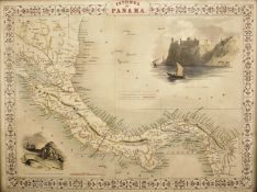
A 19th century circa 1850 Isthmus of Panama map by J. Rapkin. The illustrations by H. Warren, drawn and engraved by J. Rapkin and J. Wrightson. T...

Los 379
"Untitled" Print.
iMeasures 9.24 x 9.24Printed circa 1970sVerso is blank.Mounted to archival quality paper.

Los 422
Homer 'Ilias and Odyssea' Joshua Barnes Ed. 2 vols. Crownfield, Cambridge 1711. 4to. allegorical
Homer 'Ilias and Odyssea' Joshua Barnes Ed. 2 vols. Crownfield, Cambridge 1711. 4to. allegorical engraved frontispiece in Vol 1. text in Greek wit...

A 19th century circa 1850 map of Scotland. The map was illustrated by N. Whittock, drawn and engraved by J Rapkin. The map features excellent deta...

Vayrac (Abbé Jean de). 'Etat Present de L'Espagne ou L'on voit une geographie Historique du pays...'. 3 vols. small 8vo. Steenhouwer and Uytwerp, ...

Los 465
David Roberts Print
19th century A.D. Printed map of Egypt and Nubia with locations marked of the sketches of David Roberts, RA on his 1849 expedition; mounted in a g...

Los 466
W & A.K. Johnston's Railway Map of England and Wales, 13th Edition. The Scarborough Company,
W & A.K. Johnston's Railway Map of England and Wales, 13th Edition. The Scarborough Company, London c1930

Los 479
"Untitled" Print.
iMeasures 9.24 x 9.24Printed circa 1970sVerso is blank.Mounted to archival quality paper.

Johnston (Robert). 'Historia Rerum Britannicarum ut et Multarum Gallicarum, Belgicarum and Germanicarum...'. Ravestyn, Amsterdam 1655. 737pp plus ...

Taschen - Joan Blaeu Atlas Maior of 1665 hardback books with sleeve. Two reprinted collections of maps by Joan Blaeu comprising of Anglia, Scotia ...

rettangolare e ornato da grande cartouche floreale in marmi policromi diversi, in bordo filettato, montato su tavolo su base con cornice a legno p...

Coxe (William) Travels in Poland, Russia, Sweden and Denmark. Illustrated by charts and engravings. 3/5 vols. 5th Ed. Cadell and Davies, London 18...

Los 530
Seven Years War (1756-1763) Anon:- 'Theatre de la Guerre Derniere en Allemagne...' 2nd Ed. 6 vols.
Seven Years War (1756-1763) Anon:- 'Theatre de la Guerre Derniere en Allemagne...' 2nd Ed. 6 vols. 12mo. Langlois, Paris 1768 with c70. folding ma...

Los 545
Smith (C) 'Smith's Classical Atlas containing District Maps of the Countries described in Ancient
545Smith (C) 'Smith's Classical Atlas containing District Maps of the Countries described in Ancient
Smith (C) 'Smith's Classical Atlas containing District Maps of the Countries described in Ancient History both Sacred and Profane' London 1820. Co...

Disneyland Cinderella castle blueprintMeasures 34 x 23 inches

Quantity of Roleplaying maps & figures. Consisiting of paper & card maps to include Dungeons & Dragons, metal & plastic figures. Unchecked for com...

1st-4th century A.D. Mainly domestic ware fragments, mortaria, amphorae and other types; in a wooden collector's tray, some with inked inscription...

1st-4th century A.D. Including mainly rim fragments, one with the pouring lip; on marked 'Colchester / CM/23', another with 'Col / CM/19'. 1.64 k...

Los 703
Barrow - General Chart Pekin
Asien.- Barrow, J. A general chart, on Mercator's Projection, to shew the track of the Lion and Hindostan from England to the Gulph of Pekin in Ch...

Danckwerth.- 6 kolorierte Kupferstichkarten von J. Mejer aus Danckwerth, Newe Landesbeschreibung, Husum, 1652 bzw. Amsterdam, Blaew, 1662. Je ca. ...

Danckwerth.- Konvolut von ca. 100 Kupferstichkarten (mit zahlreichen Dubletten) von J. Mejer aus Danckwerth, Newe Landesbeschreibung, Husum, 1652....

Los 706
Braun-Hogenberg - Eckernförde
Eckernförde.- Ekelenforda antiquum Holsatiae ad Oceanum peninsulare oppidum. Kolor. Kupferstich von Braun u. Hogenberg, um 1590. 35 x 47 cm. Gerah...

Los 709
Mejer - Sudertheill Gottorf
Gottorf.- Sudertheill des Amptes Gottorf. Kolor. Kupferstich von J. Mejer aus Danckwerth, 1652. 40 x 60 cm. Gerahmt.Das Gebiet nördlich der Eider,...

Holstein.- Holsatiae descrip. Altkolor. Kupferstichkarte von Marcus Jordanus bei Ortelius, 1585. 33,5 x 24 cm. Hinter Glas gerahmt.Die schöne Kart...

Los 720
Konvolut 25 Kupferstiche
Konvolut von 25 Kupferstichen meist mit Ansichten, u.a. aus Happel 'Des historischen Kerns'. Um 1680. Je ca. 15 x 20 cm. Jeweils unter Passepartou...

Los 721
Konvolut von 18 Kupferstichen
Konvolut von 9 meist altkolor. Kupferstichkarten. Um 1650-1820. Meist je ca. 40 x 50 cm.Enthält: Doctecomius - Portugalliae (Falzdurchriss); Vissc...

Los 723
Speed - Kingdome of Denmarke
Speed.- The Kingdome of Denmarke. Altkolor. Kupferstichkarte von John Speed aus: A Prospect of the most famous parts of the World'. 1626. 39 x 51 ...

Los 724
Mejer - Wagrien
Wagrien.- Wagriae Pars Septentrionalis cum praefectura Cismar et Oldenburgh. Kolor. Kupferstichkarte von J. Mejer, gestoch. von Ch. Rothgiesser, b...

1st-4th century A.D. Irregular kiln slag fragments with various inclusions. 1.33 kg total, 4.6-12.4 cm (1 3/4 - 4 7/8 in.). Found Colchester, Ess...