

A voucher for 6 months toll pass at Bathampton Toll Bridge.
Antike Landkarten kaufen
34 Los(e)
Sortieren nach:
- Land
- Liste
- Galerie
-
34 Los(e)/Seite

Circuit Maps signed by Michele Alboreto and Nelson Piquet, one circuit Kyalami, annotated in blue pen and signed by Nelson Piquet in blue pen,30 x...

Los 34
CHILDREN'S HAIRCUT AT HOME
At home haircut for up to 3 children at a mutually agreed time by a professional hairdresser (within a 1-mile radius of Bathford).

A collection of eleven 19th century maps of Russia and Siberia, some hand-coloured or with coloured borders. The lot including eight examples by J...

Los 40
PHYSICS TUITION SESSION
A physics tuition session (GSCE/A-Level) with a senior lecturer of engineering from Bristol University - within a 1-mile radius of Bathford.

Los 46
A 19th century embroidered map of England and Wales with a floral border 54cm diameter. mounted in a
A 19th century embroidered map of England and Wales with a floral border 54cm diameter. mounted in a gilded frame. Some discolouration and marks

Los 64
An early 19th century map of the county of Wiltshire by Christopher Greenwood 109cm x 150cm Corner
64An early 19th century map of the county of Wiltshire by Christopher Greenwood 109cm x 150cm Corner
An early 19th century map of the county of Wiltshire by Christopher Greenwood 109cm x 150cmCorner missing around the title. marks and damages.

Los 192
The War in India: Despatches of the Rt. Hon. Lt. General Viscount Hardinge, Governor-General of ...
The War in India: Despatches of the Rt. Hon. Lt. General Viscount Hardinge, Governor-General of India, the Right-Honourable General Lord Gough, Co...

After Michael Drayton (British, 1563-1631) - An etching on paper and hand coloured map of Glocestershyre (sic - Gloucestershire), from the poetic ...

1st millennium B.C. A round-section rod coiled and partly flattened to form a hair ornament. See Taylor, J.T., Bronze Age Goldwork of the British ...

Los 370
India:- King (W) and Pope (T.A.) Compilers. 'Gold, Copper and Lead in the Chota Nagpore and adjacent
India:- King (W) and Pope (T.A.) Compilers. 'Gold, Copper and Lead in the Chota Nagpore and adjacent Country with map (large folding) showing the...
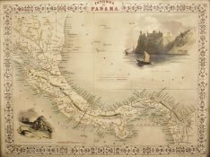
A 19th century circa 1850 Isthmus of Panama map by J. Rapkin. The illustrations by H. Warren, drawn and engraved by J. Rapkin and J. Wrightson. T...

Los 422
Homer 'Ilias and Odyssea' Joshua Barnes Ed. 2 vols. Crownfield, Cambridge 1711. 4to. allegorical
Homer 'Ilias and Odyssea' Joshua Barnes Ed. 2 vols. Crownfield, Cambridge 1711. 4to. allegorical engraved frontispiece in Vol 1. text in Greek wit...

A 19th century circa 1850 map of Scotland. The map was illustrated by N. Whittock, drawn and engraved by J Rapkin. The map features excellent deta...

Vayrac (Abbé Jean de). 'Etat Present de L'Espagne ou L'on voit une geographie Historique du pays...'. 3 vols. small 8vo. Steenhouwer and Uytwerp, ...

Los 465
David Roberts Print
19th century A.D. Printed map of Egypt and Nubia with locations marked of the sketches of David Roberts, RA on his 1849 expedition; mounted in a g...

Los 466
W & A.K. Johnston's Railway Map of England and Wales, 13th Edition. The Scarborough Company,
W & A.K. Johnston's Railway Map of England and Wales, 13th Edition. The Scarborough Company, London c1930

Johnston (Robert). 'Historia Rerum Britannicarum ut et Multarum Gallicarum, Belgicarum and Germanicarum...'. Ravestyn, Amsterdam 1655. 737pp plus ...

Taschen - Joan Blaeu Atlas Maior of 1665 hardback books with sleeve. Two reprinted collections of maps by Joan Blaeu comprising of Anglia, Scotia ...

Coxe (William) Travels in Poland, Russia, Sweden and Denmark. Illustrated by charts and engravings. 3/5 vols. 5th Ed. Cadell and Davies, London 18...

Los 530
Seven Years War (1756-1763) Anon:- 'Theatre de la Guerre Derniere en Allemagne...' 2nd Ed. 6 vols.
Seven Years War (1756-1763) Anon:- 'Theatre de la Guerre Derniere en Allemagne...' 2nd Ed. 6 vols. 12mo. Langlois, Paris 1768 with c70. folding ma...

Los 545
Smith (C) 'Smith's Classical Atlas containing District Maps of the Countries described in Ancient
545Smith (C) 'Smith's Classical Atlas containing District Maps of the Countries described in Ancient
Smith (C) 'Smith's Classical Atlas containing District Maps of the Countries described in Ancient History both Sacred and Profane' London 1820. Co...

Quantity of Roleplaying maps & figures. Consisiting of paper & card maps to include Dungeons & Dragons, metal & plastic figures. Unchecked for com...

1st-4th century A.D. Mainly domestic ware fragments, mortaria, amphorae and other types; in a wooden collector's tray, some with inked inscription...

1st-4th century A.D. Including mainly rim fragments, one with the pouring lip; on marked 'Colchester / CM/23', another with 'Col / CM/19'. 1.64 k...

1st-4th century A.D. Irregular kiln slag fragments with various inclusions. 1.33 kg total, 4.6-12.4 cm (1 3/4 - 4 7/8 in.). Found Colchester, Ess...

1st century A.D. Including burnished rim and base fragments, all but two with inked or pencilled reference notations including 'Col' for Colcheste...

Mousterian Period, 200,000-30,000 B.C. Biconvex in section with narrow point. Cf. MacGregor, A. (ed.), Antiquities from Europe and the Near East i...

Lower Palaeolithic Period, 480,000-250,000 B.C. Ovate in form with thick butt, lentoid in section, patinated white. Cf. MacGregor, A. (ed.), Antiq...

Mousterian Period, 200,000-30,000 B.C. Ovate in plan with thin, lentoid section. 96 grams, 85 mm (3 3/8 in.). Found Plazac, France. From an old F...

Circa 1840 A.D. Antique woodcut map of lower Japanese islands (Kyushu, Shikoku, Honshu) with very extensive detail depicting towns, villages, temp...

19th century A.D. Penannular round-section bracelet with clubbed ends. 73.2 grams, 58 mm (1 1/4 in.). From the shipwrecked English Schooner 'Duor...

19th century A.D. Group of two penannular round-section bracelets with clubbed ends. 150 grams total, 59-63 mm (2 3/8 - 2 1/2 in.). From the ship...

19th century A.D. Group of two penannular round-section bracelets with clubbed ends. 155 grams total, 57 mm each (2 1/4 in.). From the shipwrecke...