Verfeinern Sie Ihre Suche
Auktionshaus-Kategorie
Kategorie
Sortieren nach:
- Kategorie
- Liste
- Galerie
-
12 Los(e)/Seite
Ein Abonnement der Preisliste ist notwendig um Ergebnisse, von Auktionen die vor einem längeren Zeitraum als 10 Tagen stattgefunden haben, ansehen zu können. Klicken Sie hier für mehr Informationen
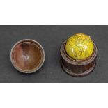

An early 19th century pocket globe, 3cm diameter, revolving in a turned mahogany case with pull-off domed cover, 5cm high.Illustrated
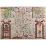
John Speed, 1610, Buckingham, Both Shyre and Shire Towne described (sic), hand coloured engraved map with plans of Buckingham and Redding, text to...
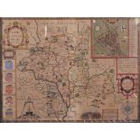
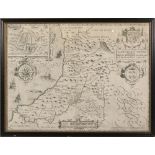
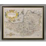
A coloured engraved map, Worcestershire, described by Christopher Saxton and published by John Speed, engraved by Jodocus Hondius, 1610, with plan...
An engraved map, Worcestershire, described by Christopher Saxton and published by John Speed,
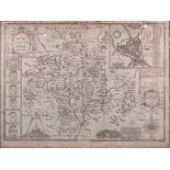
An engraved map, Worcestershire, described by Christopher Saxton and published by John Speed, engraved by Jodocus Hondius, 1610, uncoloured, with ...
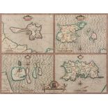
John Speed, 1610; an engraved map of the Channel Islands, Holy Island, Garnsey, Farne and Iarsey (sic), engraved by Jocodus Hondius, 1610, 38.5 x ...
John Speed, 1610,
John Speed, 1610, Cardigan Shyre described with the due forme of the shiretown as it was surveyed by I. S. Anno 1610, engraved by Jocodus Hondius,...
TOUCEY (Hon. Isaac) Explanations and Sailing Directions.... Wind And Current Charts, 2 volumes, Washington: 1858, full cloth and Close's Fisherman...
Richard Blome, 1671; A general Mapp of Dorsetshire (sic), hand coloured engraved map, 26 x 32cm.
Richard Blome, 1671; A general Mapp of Dorsetshire (sic), hand coloured engraved map, 26 x 32cm.
A hand coloured engraved map of Somerseet, circa 1610, titled 'Somersettensis', survey by Christopher Saxton and engraved by William Kip, 28 x 39c...
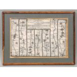
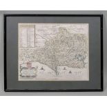
Thomas Gardner; The Road from London to Pool in the county of Dorset, a hand coloured engraved strip map, 17 x 27cm, together with another strip m...
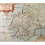
A hand coloured and engraved map of Pembrokeshire, circa 1610, titled 'Penbrok' surveyed by George Owen and engraved by William Kip, 29 x 34cm.Ill...
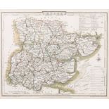
John Cary; Suffolk, a hand coloured engraved map, published 1787 by J Carey, 22 x 27cm, together with five other maps to include: Cheshire by Robe...
-
12 Los(e)/Seite