Mindestpreis nicht eingehalten Keine Abbildung Los 1 ASHER AND ADAMS Asher & Adams' New Historical and Topographical Atlas of the United States. With... 1ASHER AND ADAMS Asher & Adams' New Historical and Topographical Atlas of the United States. With... Bonhams ASHER AND ADAMS Asher & Adams' New Historical and Topographical Atlas of the United States. With Maps Showing the Dominion of Canada, Europe and t... Auf die Merkliste Timed
Mindestpreis nicht eingehalten Keine Abbildung Los 2 BLAEU (JAN) Delfi Batavorum vernacule Delft, [Amsterdam, 1649 or later]; BLAEU (WILLEM) Novus X... 2BLAEU (JAN) Delfi Batavorum vernacule Delft, [Amsterdam, 1649 or later]; BLAEU (WILLEM) Novus X... Bonhams BLAEU (JAN) Delfi Batavorum vernacule Delft, hand-coloured engraved double-page plan of the city of Delft, Latin text on verso, remnants of archi... Auf die Merkliste Timed
Mindestpreis nicht eingehalten Keine Abbildung Los 3 BLAEU (WILLEM AND JAN) Toonneel des Aerdrycz, oft Nieuwe Atlas... Tweede Deels, 2 parts in 1 vol... 3BLAEU (WILLEM AND JAN) Toonneel des Aerdrycz, oft Nieuwe Atlas... Tweede Deels, 2 parts in 1 vol... Bonhams BLAEU (WILLEM AND JAN) Toonneel des Aerdrycz, oft Nieuwe Atlas... Tweede Deels, 2 parts in 1 vol., engraved architectural and allegorical titles ... Auf die Merkliste Timed
Mindestpreis nicht eingehalten Keine Abbildung Los 4 BLAEU (WILLEM AND JAN) Toonneel des Aerdrycks oft Nieuwe Atlas...Vierde Deel, Amsterdam, Jan Bla... 4BLAEU (WILLEM AND JAN) Toonneel des Aerdrycks oft Nieuwe Atlas...Vierde Deel, Amsterdam, Jan Bla... Bonhams BLAEU (WILLEM AND JAN) Toonneel des Aerdrycks oft Nieuwe Atlas...Vierde Deel, engraved title and 58 engraved maps, marginal damp-staining, small ... Auf die Merkliste Timed
Mindestpreis nicht eingehalten Keine Abbildung Los 5 BRADFORD (THOMAS G.) A Comprehensive Atlas, Geographical, Historical & Commercial, 1835; and atl... 5BRADFORD (THOMAS G.) A Comprehensive Atlas, Geographical, Historical & Commercial, 1835; and atl... Bonhams BRADFORD (THOMAS G.) A Comprehensive Atlas, Geographical, Historical & Commercial, hand-coloured pictorial frontispiece, engraved decorative titl... Auf die Merkliste Timed
Mindestpreis nicht eingehalten Keine Abbildung Los 14 GRAY (O.W.) Gray's Atlas of the United States, with General Maps of the World, Philadelphia, Ste... 14GRAY (O.W.) Gray's Atlas of the United States, with General Maps of the World, Philadelphia, Ste... Bonhams GRAY (O.W.) Gray's Atlas of the United States, with General Maps of the World, numerous hand-coloured lithographed maps (some double-page, usuall... Auf die Merkliste Timed
Mindestpreis nicht eingehalten Keine Abbildung Los 16 SPEED (JOHN) The Kingdome of China Newly Augmented by I.S. 1626, Thomas Bassett and Richard Chis... 16SPEED (JOHN) The Kingdome of China Newly Augmented by I.S. 1626, Thomas Bassett and Richard Chis... Bonhams SPEED (JOHN) The Kingdome of China Newly Augmented by I.S. 1626, hand-coloured engraved map, decorated borders with eight costumed figures in ver... Auf die Merkliste Timed
Mindestpreis nicht eingehalten Keine Abbildung Los 16 LINFORTH (JAMES, EDITOR) Route from Liverpool, to Great Salt Lake Valley Illustrated...by Freder... 16LINFORTH (JAMES, EDITOR) Route from Liverpool, to Great Salt Lake Valley Illustrated...by Freder... Bonhams LINFORTH (JAMES, EDITOR) Route from Liverpool, to Great Salt Lake Valley Illustrated...by Frederick Piercy, FIRST EDITION, 30 engraved plates and... Auf die Merkliste Timed
Mindestpreis nicht eingehalten Keine Abbildung Los 17 MITCHELL (SAMUEL AUGUSTUS) A New Universal Atlas Containing Maps of the Various Empires, Kingdom... 17MITCHELL (SAMUEL AUGUSTUS) A New Universal Atlas Containing Maps of the Various Empires, Kingdom... Bonhams MITCHELL (SAMUEL AUGUSTUS) A New Universal Atlas Containing Maps of the Various Empires, Kingdoms, States and Republics of the World. With a Speci... Auf die Merkliste Timed
Mindestpreis nicht eingehalten Keine Abbildung Los 18 MITCHELL (SAMUEL AUGUSTUS) Mitchell's New General Atlas, Containing Maps of the Various Countrie... 18MITCHELL (SAMUEL AUGUSTUS) Mitchell's New General Atlas, Containing Maps of the Various Countrie... Bonhams MITCHELL (SAMUEL AUGUSTUS) Mitchell's New General Atlas, Containing Maps of the Various Countries of the World, Plans of Cities, Etc., 59 hand-co... Auf die Merkliste Timed
Mindestpreis nicht eingehalten Keine Abbildung Los 20 NORFOLK and SUFFOLK - SPEED (JOHN) Norfolk and Sufolk, 2 double-page engraved maps with outline ... 20NORFOLK and SUFFOLK - SPEED (JOHN) Norfolk and Sufolk, 2 double-page engraved maps with outline ... Bonhams NORFOLK and SUFFOLK SPEED (JOHN) Norfolk, a Countie Florishing & Populous Described and Devided with the Armes of such Noble Familes as have Borne... Auf die Merkliste Timed
Mindestpreis nicht eingehalten Keine Abbildung Los 22 SOCIETY FOR THE DIFFUSION OF USEFUL KNOWLEDGE The Complete Atlas of Modern, Classical and Celest... 22SOCIETY FOR THE DIFFUSION OF USEFUL KNOWLEDGE The Complete Atlas of Modern, Classical and Celest... Bonhams SOCIETY FOR THE DIFFUSION OF USEFUL KNOWLEDGE The Complete Atlas of Modern, Classical and Celestial Maps, together with Plans of the Principal Cit... Auf die Merkliste Timed
Mindestpreis nicht eingehalten Keine Abbildung Los 23 SPEED (JOHN) AND WILLEM BLAEU Pictorial title-pages to Speed's 'Theatre of the Empire of Great B... 23SPEED (JOHN) AND WILLEM BLAEU Pictorial title-pages to Speed's 'Theatre of the Empire of Great B... Bonhams SPEED (JOHN) AND WILLEM BLAEU Pictorial title-pages to Speed's 'Theatre of the Empire of Great Britain', 1650, and Blaeu's 'Le Théâtre du Monde...... Auf die Merkliste Timed
Mindestpreis nicht eingehalten Keine Abbildung Los 24 SPEED (JOHN) Yorkshire; The North and East Ridins of Yorkshire; West Ridinges, [c.1730], hand-co... 24SPEED (JOHN) Yorkshire; The North and East Ridins of Yorkshire; West Ridinges, [c.1730], hand-co... Bonhams SPEED (JOHN) Yorkshire; The North and East Ridings of Yorkshire, inset plans of Hull and Richmond; The West Ridinge of Yorkeshyre with Most Famou... Auf die Merkliste Timed
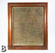
Keine Abbildung Los 28 Map of England and Wales Silk Embroidery 28Map of England and Wales Silk Embroidery British Bespoke Auctions A charming George III silk work map of England and Wales, by Elizabeth Honeley 1784, stitched on linen, approx 40.5 x 49 cms, framed and glazed. Auf die Merkliste Live
Mindestpreis nicht eingehalten Keine Abbildung Los 30 FRENCH REVOLUTION - LOUIS XVI Document signed and subscribed by the King ('Bon Louis'), Paris, 2... 30FRENCH REVOLUTION - LOUIS XVI Document signed and subscribed by the King ('Bon Louis'), Paris, 2... Bonhams FRENCH REVOLUTION - LOUIS XVI Document signed and subscribed by the King ('Bon Louis'), and his secretary, ordering Joseph Duruey, Administrator o... Auf die Merkliste Timed
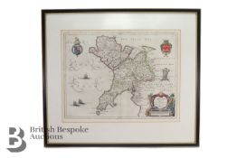
Keine Abbildung Los 31 Johannes Blaeu Map of Caernarvonshire and Anglesey and Buckinghamshire 31Johannes Blaeu Map of Caernarvonshire and Anglesey and Buckinghamshire British Bespoke Auctions Johannes Blaeu, county map Comitatus Caernarvo: Niensis Vernacule Caernarvon-shire et Mona Insula vulgo Anglesey, approx 52 x 40 cms. (Map of Cae... Auf die Merkliste Live
Keine Abbildung Los 47 Simeoni (Gabriel) Le sententiose imprese di... Paolo Giovio, et... Gabriel Symeoni, ridotte in ri... 47Simeoni (Gabriel) Le sententiose imprese di... Paolo Giovio, et... Gabriel Symeoni, ridotte in ri... Forum Auctions Simeoni (Gabriel) Le sententiose imprese di... Paolo Giovio, et... Gabriel Symeoni, ridotte in rima per il detto Symeoni., first edition, collatio... Auf die Merkliste Live
Mindestpreis nicht eingehalten Keine Abbildung Los 52 Speed (John) Wales, J. Sudbury and G. Humble, 1610 52Speed (John) Wales, J. Sudbury and G. Humble, 1610 Bonhams Speed (John) Wales, double-page hand coloured engraved map, inset views, Royal Arms, ships and sea-monsters, a further 12 views to the borders, J... Auf die Merkliste Timed
Keine Abbildung Los 52 [Moulin (Pierre du)] Tragicum Theatrum Actorum, & Casuum Tragicorum Londini Publice celebratorum,... 52[Moulin (Pierre du)] Tragicum Theatrum Actorum, & Casuum Tragicorum Londini Publice celebratorum,... Forum Auctions [Moulin (Pierre du)] Tragicum Theatrum Actorum, & Casuum Tragicorum Londini Publice celebratorum, printers woodcut device to title, 8 engraved por... Auf die Merkliste Live
Keine Abbildung Los 53 Streso (Caspar) Commentarius practicus in Actorum apostolicorum...capita priora sedecim, Amsterda... 53Streso (Caspar) Commentarius practicus in Actorum apostolicorum...capita priora sedecim, Amsterda... Forum Auctions Streso (Caspar) Commentarius practicus in Actorum apostolicorum...capita priora sedecim, title with woodcut printer's device, a few instances of ... Auf die Merkliste Live
Keine Abbildung Los 66 Corn growers & dealers.- To the Rt. Honble Wm. Pitt Chancellor of His Majesty's Exchequer. The Me... 66Corn growers & dealers.- To the Rt. Honble Wm. Pitt Chancellor of His Majesty's Exchequer. The Me... Forum Auctions Corn growers & dealers.- To the Rt. Honble Wm. Pitt Chancellor of His Majesty's Exchequer. The Memorial and Petition of the several persons...bein... Auf die Merkliste Live
Keine Abbildung Los 68 SECOND WORLD WAR SILK ESCAPE MAP - EASTERN EUROPE & GREECE 68SECOND WORLD WAR SILK ESCAPE MAP - EASTERN EUROPE & GREECE Auctioneum Ltd - East Bristol & Bath A WWII Second World War British ' escape ' silk map of Eastern Europe & Greece sheets 43 H and G. Scale 1;100,000. Folds to pocket handkerchief si... Auf die Merkliste Live
Keine Abbildung Los 93 Fuller (Thomas) The Holy State, second edition, Cambridge, R.D. for John Williams, 1648; and othe... 93Fuller (Thomas) The Holy State, second edition, Cambridge, R.D. for John Williams, 1648; and othe... Forum Auctions Fuller (Thomas) The Holy State, second edition, engraved additional title and portrait illustrations by William Marshall, additional title soiled ... Auf die Merkliste Live
Mindestpreis nicht eingehalten Keine Abbildung Los 106 Lt Col. Valentine Blacker CB. (British, 1778-1826) Satara from the NNE unframed 106Lt Col. Valentine Blacker CB. (British, 1778-1826) Satara from the NNE unframed Bonhams Lt Col. Valentine Blacker CB. (British, 1778-1826) Satara from the NNE inscribed and dated '11th February 1818' pen & ink 23 x 14cm (9 1/16 x 5 1... Auf die Merkliste Timed
Mindestpreis nicht eingehalten Keine Abbildung Los 124 AFRICA MUNSTER (SEBASTIAN) Africa Lybia Morenlandt mit allen königreichen so zu unsern zeit... 124AFRICA MUNSTER (SEBASTIAN) Africa Lybia Morenlandt mit allen königreichen so zu unsern zeit... Bonhams AFRICA MUNSTER (SEBASTIAN) Africa Lybia Morenlandt mit allen königreichen so zu unsern zeiten darin gefunden werden, hand-coloured woodcut map, l... Auf die Merkliste Timed
Mindestpreis nicht eingehalten Keine Abbildung Los 125 AFRICA BLAEU (WILLEM) Africae nova descriptio, [c. 1630 or later] 125AFRICA BLAEU (WILLEM) Africae nova descriptio, [c. 1630 or later] Bonhams AFRICA BLAEU (WILLEM) Africae nova descriptio, hand-coloured engraved double-page map, 10 costumed figures on the vertical margins and 9 oval vig... Auf die Merkliste Timed
Mindestpreis nicht eingehalten Keine Abbildung Los 126 LONDON STOW (JOHN) A Survey of the Cities of London and Westminster... Corrected, Improved, and ... 126LONDON STOW (JOHN) A Survey of the Cities of London and Westminster... Corrected, Improved, and ... Bonhams LONDON STOW (JOHN) A Survey of the Cities of London and Westminster... Corrected, Improved, and Very Much Enlarged... to the Present Time; by John... Auf die Merkliste Timed
Mindestpreis nicht eingehalten Keine Abbildung Los 126 AFRICA HONDIUS (HENRICUS) Africae nova Tabula, 1631 126AFRICA HONDIUS (HENRICUS) Africae nova Tabula, 1631 Bonhams AFRICA HONDIUS (HENRICUS) Africae nova Tabula, double-page hand-coloured engraved map, numerous ships, sea-monsters, animals (elephants, lions, c... Auf die Merkliste Timed
Mindestpreis nicht eingehalten Keine Abbildung Los 127 AFRICA L'Afrique suivant les dernières observations de M. Hass... Paris, Georges-Louis Le R... 127AFRICA L'Afrique suivant les dernières observations de M. Hass... Paris, Georges-Louis Le R... Bonhams AFRICA L'Afrique suivant les dernières observations de M. Hass et des RR. PP. Jésuites, engraved map with hand-coloured outlines, light toning,49... Auf die Merkliste Timed
Mindestpreis nicht eingehalten Keine Abbildung Los 128 AFRICA DE WIT (FREDERICK) Totius Africae Accuratissima Tabula,Amsterdam, Frederick de Wit, [c.16... 128AFRICA DE WIT (FREDERICK) Totius Africae Accuratissima Tabula,Amsterdam, Frederick de Wit, [c.16... Bonhams AFRICA DE WIT (FREDERICK) Totius Africae Accuratissima Tabula, hand-coloured double-page engraved map, decorative title cartouche, animal vignett... Auf die Merkliste Timed
Mindestpreis nicht eingehalten Keine Abbildung Los 129 WEST AFRICA HONDIUS (JODOCUS) Guineae Nova Descriptio, [Amsterdam, after 1619]; BLAEU (WILLEM) G... 129WEST AFRICA HONDIUS (JODOCUS) Guineae Nova Descriptio, [Amsterdam, after 1619]; BLAEU (WILLEM) G... Bonhams WEST AFRICA HONDIUS (JODOCUS) Guineae Nova Descriptio, hand-coloured engraved double-page map, title cartouche and inset map of St. Thomas, Frenc... Auf die Merkliste Timed
Mindestpreis nicht eingehalten Keine Abbildung Los 130 WEST AFRICA DE WIT (FREDERICK) Tractus Littorales Guineae a Promontorio Verde usque ad Sinum Cat... 130WEST AFRICA DE WIT (FREDERICK) Tractus Littorales Guineae a Promontorio Verde usque ad Sinum Cat... Bonhams WEST AFRICA DE WIT (FREDERICK) Tractus Littorales Guineae a Promontorio Verde usque ad Sinum Catenbelae, hand-coloured engraved double-page map, ... Auf die Merkliste Timed
Mindestpreis nicht eingehalten Keine Abbildung Los 131 ETHIOPIA ORTELIUS (ABRAHAM) Presbiteri Iohannis, sive, Abissinorum Imperii Descriptio, [1573 or ... 131ETHIOPIA ORTELIUS (ABRAHAM) Presbiteri Iohannis, sive, Abissinorum Imperii Descriptio, [1573 or ... Bonhams ETHIOPIA ORTELIUS (ABRAHAM) Presbiteri Iohannis, sive, Abissinorum Imperii Descriptio, hand-coloured engraved double-page map, large cartouche wi... Auf die Merkliste Timed
Mindestpreis nicht eingehalten Keine Abbildung Los 132 EAST AFRICA DE WIT (FREDERICK) Occidentalior Tractus Indiarum Orientalium a Promontorio Bonae Sp... 132EAST AFRICA DE WIT (FREDERICK) Occidentalior Tractus Indiarum Orientalium a Promontorio Bonae Sp... Bonhams EAST AFRICA DE WIT (FREDERICK) Occidentalior Tractus Indiarum Orientalium a Promontorio Bonae Spei ad C. Comorin, hand-coloured engraved double-p... Auf die Merkliste Timed
Mindestpreis nicht eingehalten Keine Abbildung Los 133 ETHIOPIA, SOUTH AFRICA AND MADAGASCAR BLAEU (WILLEM) Aethiopia Superior vel Interior, [Amsterdam... 133ETHIOPIA, SOUTH AFRICA AND MADAGASCAR BLAEU (WILLEM) Aethiopia Superior vel Interior, [Amsterdam... Bonhams ETHIOPIA, SOUTH AFRICA AND MADAGASCAR BLAEU (WILLEM) Aethiopia Superior vel Interior vulgo Abissinorum sive Presbiteri Joannis Imperium, hand-col... Auf die Merkliste Timed
Mindestpreis nicht eingehalten Keine Abbildung Los 136 SEVEN CONIC PROJECTION MAPS T/W BRITISH EMPIRE MAPS 136SEVEN CONIC PROJECTION MAPS T/W BRITISH EMPIRE MAPS Auctioneum Ltd - East Bristol & Bath A collection of seven 20th century Conic Projection maps together with another. The lot to include: the map of Iran (Persia) scale 1:4,000,000 pla... Auf die Merkliste Timed
Mindestpreis nicht eingehalten Keine Abbildung Los 149 BERNADIN DE SAINT PIERRE (JACQUES) A Voyage to the Isle of France, the Isle of Bourbon, and the ... 149BERNADIN DE SAINT PIERRE (JACQUES) A Voyage to the Isle of France, the Isle of Bourbon, and the ... Bonhams BERNADIN DE SAINT PIERRE (JACQUES) A Voyage to the Isle of France, the Isle of Bourbon, and the Cape of Good Hope, half-title, 4 hand-coloured fo... Auf die Merkliste Timed
Mindestpreis nicht eingehalten Keine Abbildung Los 156 CHATELAIN (HENRY ABRAHAM)] Atlas historique... vol. 6 (with Africa section only), 1719; and 3 ot... 156CHATELAIN (HENRY ABRAHAM)] Atlas historique... vol. 6 (with Africa section only), 1719; and 3 ot... Bonhams [CHATELAIN (HENRY ABRAHAM)] Atlas historique, ou nouvelle introduction a l'histoire..., vol. 6 (with Africa section only), title printed in red a... Auf die Merkliste Timed
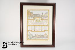
Keine Abbildung Los 159 Ben Warwick Commemorative Print 159Ben Warwick Commemorative Print British Bespoke Auctions Ben Warwick commemorative print, 'On the Occasion of the Golden Jubilee of Her Majesty The Queen for the district of Rutland' depicting The Market... Auf die Merkliste Live
Keine Abbildung Los 184 Juvenilia.- A Present for A Little Girl, 1820; bound with 3 others, William Darton. 184Juvenilia.- A Present for A Little Girl, 1820; bound with 3 others, William Darton. Forum Auctions Juvenilia.- A Present for A Little Girl, engraved hand-coloured vignette on title, 27 brightly hand-coloured wood-engraved illustrations (3 full-p... Auf die Merkliste Live
Mindestpreis nicht eingehalten Keine Abbildung Los 199 ROGERS (WOODES) A Cruising Voyage Round the World: First to the South-Sea, thence to the East-In... 199ROGERS (WOODES) A Cruising Voyage Round the World: First to the South-Sea, thence to the East-In... Bonhams ROGERS (WOODES) A Cruising Voyage Round the World: First to the South-Sea, thence to the East-Indies, and Homewards by the Cape of Good Hope, Begu... Auf die Merkliste Timed
Mindestpreis nicht eingehalten Keine Abbildung Los 211 THAILAND AND EAST ASIA TACHARD (GUY) Reis Na Siam, Amsterdam, A.D. Oossaan, 1687; and 11 others ... 211THAILAND AND EAST ASIA TACHARD (GUY) Reis Na Siam, Amsterdam, A.D. Oossaan, 1687; and 11 others ... Bonhams THAILAND and EAST ASIA TACHARD (GUY) Reis Na Siam edaan door den Ridder de Chaumont, in't Nederduitsch gebracht door G. V. Broekhuizen, additiona... Auf die Merkliste Timed
Keine Abbildung Los 247 British Isles.- Blaeu (Johannes) Britannia prout divisa suit temporibus Anglo-Saxonum, praesertim... 247British Isles.- Blaeu (Johannes) Britannia prout divisa suit temporibus Anglo-Saxonum, praesertim... Forum Auctions British Isles.- Blaeu (Johannes) Britannia prout divisa suit temporibus Anglo-Saxonum, praesertim durante illorum Heptarchia, map of the British I... Auf die Merkliste Live
Keine Abbildung Los 248 British Isles.- Speed (John) Britain as it was devided in the tyme of the Englishe Saxons especia... 248British Isles.- Speed (John) Britain as it was devided in the tyme of the Englishe Saxons especia... Forum Auctions British Isles.- Speed (John) Britain as it was devided in the tyme of the Englishe Saxons especially during their Heptarchy, first edition, decora... Auf die Merkliste Live
Keine Abbildung Los 250 England.- Canals.- Bradshaw (George) Map of Canals, Navigable Rivers, Railroads etc. of the Midla... 250England.- Canals.- Bradshaw (George) Map of Canals, Navigable Rivers, Railroads etc. of the Midla... Forum Auctions England.- Canals.- Bradshaw (George) Map of Canals, Navigable Rivers, Railroads etc. of the Midland Counties of England from Actual Survey, map ce... Auf die Merkliste Live
Keine Abbildung Los 251 England & Wales.- Ramsay (Andrew C.) Geological Map of England & Wales, lithographic map, 1859 251England & Wales.- Ramsay (Andrew C.) Geological Map of England & Wales, lithographic map, 1859 Forum Auctions England & Wales.- Ramsay (Andrew C.) Geological Map of England & Wales, lithographic map with full hand-colouring, sheet 975 x 840 mm (38 1/2 x 33... Auf die Merkliste Live
Keine Abbildung Los 252 England & Wales.- Speed (John) The Kingdome of England, engraved map, engraved map, [c. 1676] 252England & Wales.- Speed (John) The Kingdome of England, engraved map, engraved map, [c. 1676] Forum Auctions England & Wales.- Speed (John) The Kingdome of England, eight costumed figures in margins, the seas populated with monsters and ships, engraving w... Auf die Merkliste Live
Keine Abbildung Los 253 Geology of the British Isles.- Geikie (Sir Archibald) Geological Map of England & Wales [together... 253Geology of the British Isles.- Geikie (Sir Archibald) Geological Map of England & Wales [together... Forum Auctions Geology of the British Isles.- Geikie (Sir Archibald) Geological Map of England & Wales [together with] Geological Map of Ireland [together with] ... Auf die Merkliste Live
Keine Abbildung Los 255 London.- Andrews (John) Andrews's New and Accurate Map of the Country Thirty Miles round London, ... 255London.- Andrews (John) Andrews's New and Accurate Map of the Country Thirty Miles round London, ... Forum Auctions London.- Andrews (John) Andrews's New and Accurate Map of the Country Thirty Miles round London, third edition, engraved map with hand-colouring, ... Auf die Merkliste Live
Keine Abbildung Los 256 London.- Cruchley (George Frederick) Cruchley's New Plan of London Shewing all the New and Intend... 256London.- Cruchley (George Frederick) Cruchley's New Plan of London Shewing all the New and Intend... Forum Auctions London.- Cruchley (George Frederick) Cruchley's New Plan of London Shewing all the New and Intended Improvements to the Present Time, engraved map... Auf die Merkliste Live
Keine Abbildung Los 257 London.- Mogg (Edward) An Entire New Plan of the Cities of London & Westminster with the Borough ... 257London.- Mogg (Edward) An Entire New Plan of the Cities of London & Westminster with the Borough ... Forum Auctions London.- Mogg (Edward) An Entire New Plan of the Cities of London & Westminster with the Borough of Southwark, Comprehending the New Buildings and... Auf die Merkliste Live
Keine Abbildung Los 258 London.- Mogg (Edward) Mogg's Strangers Guide to London, exhibiting all the various alterations &... 258London.- Mogg (Edward) Mogg's Strangers Guide to London, exhibiting all the various alterations &... Forum Auctions London.- Mogg (Edward) Mogg's Strangers Guide to London, exhibiting all the various alterations & improvements complete to the present time, engra... Auf die Merkliste Live
Keine Abbildung Los 260 France.- Speed (John) France revised and augmented..., engraved map, [1676] 260France.- Speed (John) France revised and augmented..., engraved map, [1676] Forum Auctions France.- Speed (John) France revised and augmented..., 'carte-a-figure' map of France, with 10 costumed figures to the vertical margins and 8 oval... Auf die Merkliste Live
Keine Abbildung Los 261 London.- Wallis (J. & E.) The City of London, in the Time of the Saxons (about the Year 1000), en... 261London.- Wallis (J. & E.) The City of London, in the Time of the Saxons (about the Year 1000), en... Forum Auctions London.- Wallis (J. & E.) The City of London, in the Time of the Saxons (about the Year 1000) Compiled from the Most Authentic Documents, historic... Auf die Merkliste Live
Keine Abbildung Los 265 China.- Jansson (Jan) China Veteribus Sinarum Regio nunc Incolis Tame dicta, engraved map, [c. 1635] 265China.- Jansson (Jan) China Veteribus Sinarum Regio nunc Incolis Tame dicta, engraved map, [c. 1635] Forum Auctions China.- Jansson (Jan) China Veteribus Sinarum Regio nunc Incolis Tame dicta, map of Eastern China, with Japan, Korea as an island, and the norther... Auf die Merkliste Live
Keine Abbildung Los 269 River Nile.- Stanford (Edward) A Map of the Nile, from the Equatorial Lakes to the Mediterranean,... 269River Nile.- Stanford (Edward) A Map of the Nile, from the Equatorial Lakes to the Mediterranean,... Forum Auctions River Nile.- Stanford (Edward) A Map of the Nile, from the Equatorial Lakes to the Mediterranean, Embracing the Egyptian Sudan (Kordofan, Darfur, ... Auf die Merkliste Live
Keine Abbildung Los 270 Saint Helena.- Read (Lieut. R.P.) Geographical Plan of The Island & Forts of Saint Helena, engrav... 270Saint Helena.- Read (Lieut. R.P.) Geographical Plan of The Island & Forts of Saint Helena, engrav... Forum Auctions Saint Helena.- Read (Lieut. R.P.) Geographical Plan of The Island & Forts of Saint Helena, the island orientated with north to the lower left corn... Auf die Merkliste Live
Keine Abbildung Los 294 COLLECTION OF WWII SECOND WORLD WAR ORDNANCE SURVEY MAPS 294COLLECTION OF WWII SECOND WORLD WAR ORDNANCE SURVEY MAPS Auctioneum Ltd - East Bristol & Bath A collection of x4 WWII Second World War British War Office Ordnance Survey maps. All dated 1940 comprising Hull, Great Driffield & Bridlington, Y... Auf die Merkliste Live
Keine Abbildung Los 320 COLLECTION OF RAF AND WARTIME ORDNANCE SURVEY MAPS 320COLLECTION OF RAF AND WARTIME ORDNANCE SURVEY MAPS Auctioneum Ltd - East Bristol & Bath A collection of approximately x80 RAF Royal Air Force and wartime OS maps comprising x20 RAF maps from the 1939-45 period including maps of Englan... Auf die Merkliste Live


![BLAEU (JAN) Delfi Batavorum vernacule Delft, [Amsterdam, 1649 or later]; BLAEU (WILLEM) Novus X...](https://portal-images.azureedge.net/auctions-2024/bonham10855/images/73460c6e-1380-48e8-bc29-b179011a54d5.jpg?h=175)


![SPEED (JOHN) Yorkshire; The North and East Ridins of Yorkshire; West Ridinges, [c.1730], hand-co...](https://portal-images.azureedge.net/auctions-2024/bonham10855/images/38d5b31b-fc81-4c30-82bb-b179011a54ac.jpg?h=175)


![[Moulin (Pierre du)] Tragicum Theatrum Actorum, & Casuum Tragicorum Londini Publice celebratorum,...](https://portal-images.azureedge.net/auctions-2024/forum-10424/images/b97cc6e6-3a73-4253-b964-b18600bc3202.jpg?h=175)


![AFRICA BLAEU (WILLEM) Africae nova descriptio, [c. 1630 or later]](https://portal-images.azureedge.net/auctions-2024/bonham10791/images/d70693cb-2c26-42a3-9d72-b17a010d6222.jpg?h=175)


![WEST AFRICA HONDIUS (JODOCUS) Guineae Nova Descriptio, [Amsterdam, after 1619]; BLAEU (WILLEM) G...](https://portal-images.azureedge.net/auctions-2024/bonham10791/images/60cf56e9-8579-461d-a2ef-b17a010d721a.jpg?h=175)


![CHATELAIN (HENRY ABRAHAM)] Atlas historique... vol. 6 (with Africa section only), 1719; and 3 ot...](https://portal-images.azureedge.net/auctions-2024/bonham10791/images/042d00a5-0aa0-4a70-95b3-b17a010d9cce.jpg?h=175)


![England & Wales.- Speed (John) The Kingdome of England, engraved map, engraved map, [c. 1676]](https://portal-images.azureedge.net/auctions-2024/forum-10424/images/d1ea1d84-54b2-4e06-88e9-b18600be284b.jpg?h=175)


![France.- Speed (John) France revised and augmented..., engraved map, [1676]](https://portal-images.azureedge.net/auctions-2024/forum-10424/images/8dfb2f8d-fa12-4aea-9cfc-b18600be42ca.jpg?h=175)

![China.- Jansson (Jan) China Veteribus Sinarum Regio nunc Incolis Tame dicta, engraved map, [c. 1635]](https://portal-images.azureedge.net/auctions-2024/forum-10424/images/1ad85938-ab4f-44c7-8e2f-b18600be5452.jpg?h=175)


