


A large vintage 1950s (1959) sales promotion wall hanging map of the British Isles. Scale 1:633,600 or 10 miles per inch. Measures approx 150x170c...
Sammlerobjekte Auktionen
Beliebte Kategorien
Antike Landkarten
Musikinstrumente & Memorabilia
Banknoten & Wertpapiere
Sport Memorabilia & Ausrüstungen
Briefmarken
Schreibgeräte
Kameras & Fotoausrüstungen
Unterhaltung Memorabilia
Religiöse & Sakrale Kunst
Wissenschaftliche Instrumente
Waffen, Rüstungen & Militaria
Wein & Spirituosen
Präparate & Naturkundliches
Küchenutensilien
Werkzeug
Eisenbahngeschichte
Ausgewählte Auktionen
Kommende Auktionen

216 Los(e)
Sortieren nach:
- Kategorie
- Liste
- Galerie
-
216 Los(e)/Seite
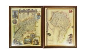
Two 20th Century reproduction maps of South-West interest, featuring a map of 'Somersetshire', dated '1836', and a map of 'Gloucestershire'. Both ...

Wandatlas "Der Krieg von 1866", Karte aus mehreren Teilen zusammengesetzt, auf Leinen aufgezogen, oben rechts ausführlich bezeichnet Haack-Hertzbe...

Los 72
Gerard de Jode (Nimega 1509 - Anversa 1591), “Roman Empire - Four Kingdoms”. Lotto composto da
Gerard de Jode (Nimega 1509 - Anversa 1591), “Roman Empire - Four Kingdoms”. Lotto composto da quattro incisioni su carta, H cm 20x29 (difetti) ...

A collection of seven 20th century Conic Projection maps together with another. The lot to include: the map of Iran (Persia) scale 1:4,000,000 pla...

Los 141
JAN DAVIDSZ DE HEEM (seguace di)
(Utrecht, 1606 - Anversa, 1684)Natura mortaOlio su tela, cm 80X112Provenienza: Probabilmente Parigi, Galleria Charpentier (1956, come attribuito a...

Los 153
Schleswig Holstein. Nordfriesland. Original kolorierte Kupferstichkarte von Joh. Mejer aus C.
Schleswig Holstein. Nordfriesland. Original kolorierte Kupferstichkarte von Joh. Mejer aus C. Danckwerth, Newe Landesbeschreibung ..., 1652. 2 Kar...

Saxton, Christopher (c.1540-c.1610) & William Hole (d. 1624) - A 17th century etched & hand coloured map of Oxfordshire. The map reading: Oxoniens...

Los 222
Alessandro Stefani Argentiere, Scatola ovale in argento con interno in vermeil, Bologna, XX secolo.
Alessandro Stefani Argentiere, Scatola ovale in argento con interno in vermeil, Bologna, XX secolo. Superficie riccamente lavorata a cesello e sba...

David Michael Jones (1895-1974) Map of the Third Voyage wood engraving 19 x 16cm.

Los 376
Reisen. Deutschlandkarte. Roost, J. B. Neue Wand – Karte von Deutschland den Königreichen Holland u.
Reisen. Deutschlandkarte. Roost, J. B. Neue Wand – Karte von Deutschland den Königreichen Holland u. Belgien und der Schweiz, sammt den angrenzend...

Los 465
David Roberts Print
19th century A.D. Printed map of Egypt and Nubia with locations marked of the sketches of David Roberts, RA on his 1849 expedition; mounted in a g...

Vintage Breweriana interest Whitbread & Co Ltd metal pub map of Kent, 83cm x 57cm

rettangolare e ornato da grande cartouche floreale in marmi policromi diversi, in bordo filettato, montato su tavolo su base con cornice a legno p...

Quantity of Roleplaying maps & figures. Consisiting of paper & card maps to include Dungeons & Dragons, metal & plastic figures. Unchecked for com...

1st-4th century A.D. Mainly domestic ware fragments, mortaria, amphorae and other types; in a wooden collector's tray, some with inked inscription...

1st-4th century A.D. Including mainly rim fragments, one with the pouring lip; on marked 'Colchester / CM/23', another with 'Col / CM/19'. 1.64 k...

Claire Anne Khalil (American, b. 1944). Watercolor on paper painting titled "The Blue Room" depicting a flattened view of a bedroom, 1971. Signed,...

Los 670
2 Jimmy Ernst Arboreal Artworks
Hans-Ulrich "Jimmy" Ernst (German/American, 1920-1984). Group of two artworks including:One drawing on board depicting an abstract arboreal figure...

Los 685
Nine Edwardian coloured folding maps of Sussex farms including Pebsham Farm, Court Lodge Farm, Upper
Nine Edwardian coloured folding maps of Sussex farms including Pebsham Farm, Court Lodge Farm, Upper Wiltshire Farm and Catsfield Place Farm, each...

Los 703
Barrow - General Chart Pekin
Asien.- Barrow, J. A general chart, on Mercator's Projection, to shew the track of the Lion and Hindostan from England to the Gulph of Pekin in Ch...

Danckwerth.- 6 kolorierte Kupferstichkarten von J. Mejer aus Danckwerth, Newe Landesbeschreibung, Husum, 1652 bzw. Amsterdam, Blaew, 1662. Je ca. ...

Danckwerth.- Konvolut von ca. 100 Kupferstichkarten (mit zahlreichen Dubletten) von J. Mejer aus Danckwerth, Newe Landesbeschreibung, Husum, 1652....

Los 706
Braun-Hogenberg - Eckernförde
Eckernförde.- Ekelenforda antiquum Holsatiae ad Oceanum peninsulare oppidum. Kolor. Kupferstich von Braun u. Hogenberg, um 1590. 35 x 47 cm. Gerah...

Los 709
Mejer - Sudertheill Gottorf
Gottorf.- Sudertheill des Amptes Gottorf. Kolor. Kupferstich von J. Mejer aus Danckwerth, 1652. 40 x 60 cm. Gerahmt.Das Gebiet nördlich der Eider,...

Holstein.- Holsatiae descrip. Altkolor. Kupferstichkarte von Marcus Jordanus bei Ortelius, 1585. 33,5 x 24 cm. Hinter Glas gerahmt.Die schöne Kart...

Adolf Stielers hand atlas with coloured maps

Sgt. John Lawrence "Larry" Frick (American, 1918-1992). Pen, ink, and graphite comic illustration captioned "Someone Stole the Horse" depicting tw...

Los 720
Konvolut 25 Kupferstiche
Konvolut von 25 Kupferstichen meist mit Ansichten, u.a. aus Happel 'Des historischen Kerns'. Um 1680. Je ca. 15 x 20 cm. Jeweils unter Passepartou...

Los 721
Konvolut von 18 Kupferstichen
Konvolut von 9 meist altkolor. Kupferstichkarten. Um 1650-1820. Meist je ca. 40 x 50 cm.Enthält: Doctecomius - Portugalliae (Falzdurchriss); Vissc...

Print titled "Mother's Tapestry" depicting a tapestry style composition of leaves and flowers with hand-painted white highlighting and gilt decora...

Los 723
Speed - Kingdome of Denmarke
Speed.- The Kingdome of Denmarke. Altkolor. Kupferstichkarte von John Speed aus: A Prospect of the most famous parts of the World'. 1626. 39 x 51 ...

Los 724
Mejer - Wagrien
Wagrien.- Wagriae Pars Septentrionalis cum praefectura Cismar et Oldenburgh. Kolor. Kupferstichkarte von J. Mejer, gestoch. von Ch. Rothgiesser, b...

Los 727
Pair Fritz Eichenberg Woodcuts
Fritz Eichenberg (German, 1901- 1990). Pair of woodcuts including:One depicting St. Christopher with a child on his back, 1948. Pencil signed and ...

1st-4th century A.D. Irregular kiln slag fragments with various inclusions. 1.33 kg total, 4.6-12.4 cm (1 3/4 - 4 7/8 in.). Found Colchester, Ess...

Henri Toussaint (French, 1849-1911) after Eugene Delacroix (French, 1798-1863). Etching on laid paper titled "The Coast of Morocco" depicting a bo...

1st century A.D. Including burnished rim and base fragments, all but two with inked or pencilled reference notations including 'Col' for Colcheste...

Los 1052
A Book
Titled Municipal Atlas of the Netherlands, by J. Kuyper, fifth part Zeeland by J Kuyper, fifth part Zeeland.


Los 1375
A Collection of Maps
consisting of 3 floor plans, including Veere, largest 28 x 34 cm.


Los 1396
A Map of Portugal and Spain
From Atlas Major by Frederick de Wit (1610 - 1698), 55 x 46 cm.

Mousterian Period, 200,000-30,000 B.C. Biconvex in section with narrow point. Cf. MacGregor, A. (ed.), Antiquities from Europe and the Near East i...

Lower Palaeolithic Period, 480,000-250,000 B.C. Ovate in form with thick butt, lentoid in section, patinated white. Cf. MacGregor, A. (ed.), Antiq...

Mousterian Period, 200,000-30,000 B.C. Ovate in plan with thin, lentoid section. 96 grams, 85 mm (3 3/8 in.). Found Plazac, France. From an old F...


Cased Military interest survey Radaic no 2 meter, 19cm H x 28cm W x 11cm D

Circa 1840 A.D. Antique woodcut map of lower Japanese islands (Kyushu, Shikoku, Honshu) with very extensive detail depicting towns, villages, temp...

Los 2000
Asien - Türkei -
"Stanford's Map of Part of The Turkish Empire, with Lower Egypt, the new Balkan Provinces and Greece". Altkolor. lithogr. Karte, erschienen bei E....

Los 2001
Europa - Böhmen und Mähren -
"General-Uibersichts-Karte des Königreiches Böhmen". Alt teilkolor. lithogr. Karte. Prag, Henning und Tempsky, 1850. Gesamtgr.: ca. 63 x 84 cm. - ...

Los 2002
Europa - Österreich - Wien -
"Grundriss der Kais. auch Kais. Königl. Haupt und Residenz Stadt Wien sammt ihren Vorstaedten". Grundrissplan mit umfangreicher deutscher und fran...

Los 2003
Europa - Österreich - Wien -
"Grund Riss der K. K. Haupt und Residenz Stadt Wien mit allen Vorstädten und der umliegenden Gegend". Grundrissplan. Altkolor. Kupferstich von M. ...

Los 2004
Europa - Konvolut -
23 Karten des 18. und 19. Jhdts. von verschied. Stechern und in unterschiedlichen Formaten. - In unterschiedlich vielen Segmenten auf Lwd. aufgezo...

Los 2005
Bayern - Alpen -
Der Wetterstein vom Kranzberg aus. Weiß gehöhte Bleistiftzeichnung von Hermann Stenzel (1887-1961). Sign. und dat. 1932. 24,7 x 32,3 cm. - Randuml...

Los 2006
Bayern - Andechs -
"Der Heilige Berg Andechs". Gesamtansicht mit Pilgerzug, der Ammersee mit Dießen im Hintergrund. Kupferstich (von 2 Platten) von M. Wening aus "Hi...

Los 2007
Bayern - Aschaffenburg -
"Panorama von Aschaffenburg". Stahlstich von J. J. Tanner nach F. Bamberger, bei W. Maas in Frankfurt für Th. Pergay in Aschaffenburg, um 1850. 12...

Los 2008
Bayern - Augsburg -
"La imperial citta d'Augusta". Planansicht aus der Vogelschau, links oben mit Stadtwappen, links und rechts unten zwei Kartuschen, eine davon mit ...

Los 2009
Bayern - Augsburg -
6 kolor. Kupferstiche von C. Remshard, bei J. F. Probst in Augsburg, um 1760. Je ca. 22 x 38 cm (Blattgr.: ca. 30 x 42 bis 46 cm). (57) - 2 Blätte...