56
Frankreich. - Bordeaux. - Carte maritime depuis la Rivière de Bourdeaux jusques a St Sebastien al'
1/2


Auctioneer has chosen not to publish the price of this lot
Köln
Description
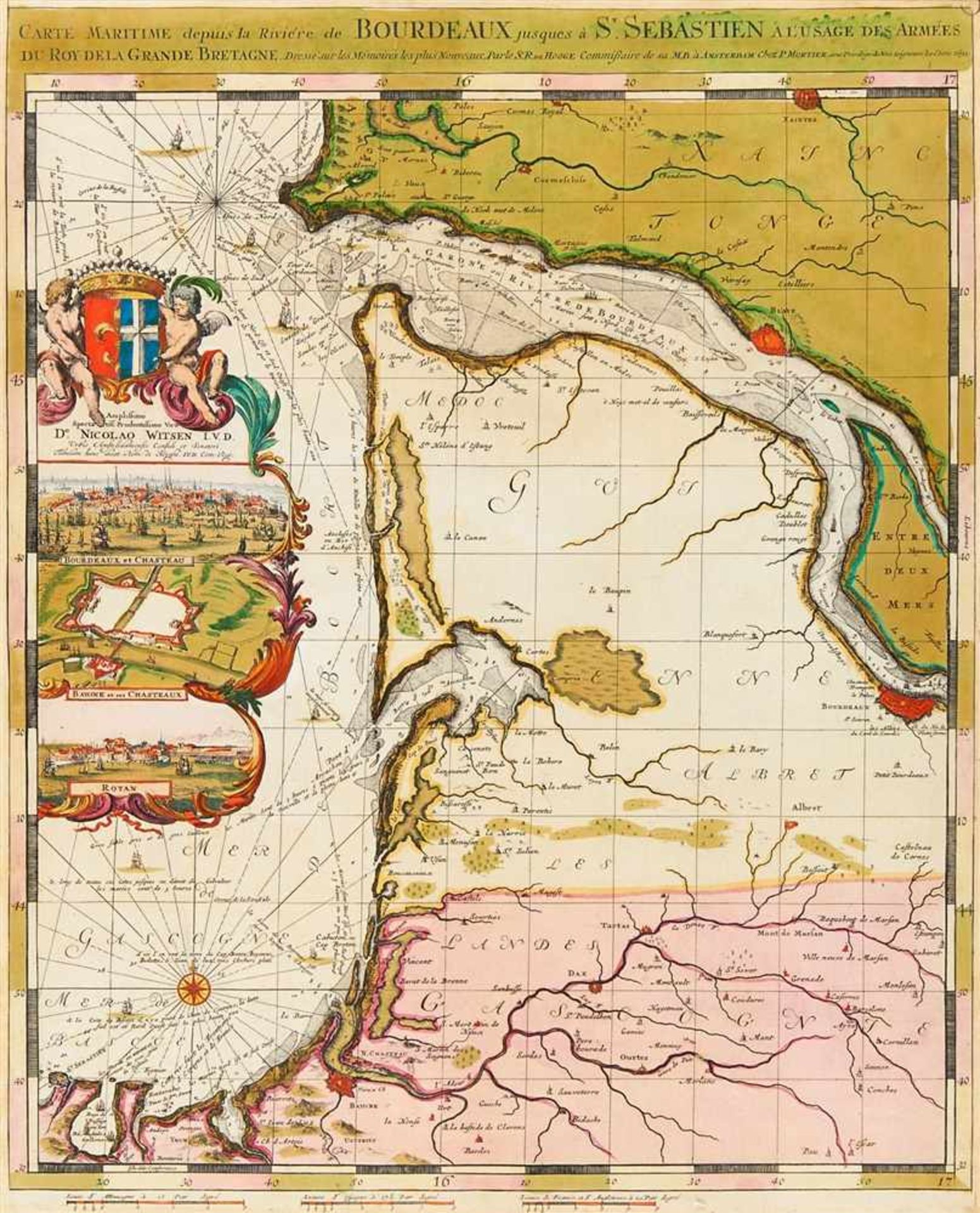
Frankreich. - Bordeaux. - Carte maritime depuis la Rivière de Bourdeaux jusques a St Sebastien al'usage des armees du Roy de la Grande Bretagne, Seekarte der Gegend um Bordeaux, mit der Mündung der Garonne, figürlicher Wappenkartusche sowie Inset-Ansichten von Bordeaux, Bayonne und Royan.
Kolorierte Kupferstichkarte bei Pierre Mortier, von Romeyn de Hooghe, 1693. Plattengröße 60,5 x 49 cm, Blattgröße 62,5 x 60 cm.
Alters- und Montagespuren, verso umlaufend Montageband. Kleinere Papierdefekte, gebräunt und stellenweise feucht- bzw. sporfleckig, Rückseite stärker betroffen.
Kolorierte Kupferstichkarte bei Pierre Mortier, von Romeyn de Hooghe, 1693. Plattengröße 60,5 x 49 cm, Blattgröße 62,5 x 60 cm.
Alters- und Montagespuren, verso umlaufend Montageband. Kleinere Papierdefekte, gebräunt und stellenweise feucht- bzw. sporfleckig, Rückseite stärker betroffen.
Auction Details
Shipping
T&Cs & Important Info
Ask seller a question
Frankreich. - Bordeaux. - Carte maritime depuis la Rivière de Bourdeaux jusques a St Sebastien al'usage des armees du Roy de la Grande Bretagne, Seekarte der Gegend um Bordeaux, mit der Mündung der Garonne, figürlicher Wappenkartusche sowie Inset-Ansichten von Bordeaux, Bayonne und Royan.
Kolorierte Kupferstichkarte bei Pierre Mortier, von Romeyn de Hooghe, 1693. Plattengröße 60,5 x 49 cm, Blattgröße 62,5 x 60 cm.
Alters- und Montagespuren, verso umlaufend Montageband. Kleinere Papierdefekte, gebräunt und stellenweise feucht- bzw. sporfleckig, Rückseite stärker betroffen.
Kolorierte Kupferstichkarte bei Pierre Mortier, von Romeyn de Hooghe, 1693. Plattengröße 60,5 x 49 cm, Blattgröße 62,5 x 60 cm.
Alters- und Montagespuren, verso umlaufend Montageband. Kleinere Papierdefekte, gebräunt und stellenweise feucht- bzw. sporfleckig, Rückseite stärker betroffen.
Spring Sales 2019
Sale Date(s)
Venue Address
Cäcilienstrasse 48
Köln
50667
Germany
For Venator & Hanstein delivery information please telephone +49 (0)221 2575419.