


A large vintage 1950s (1959) sales promotion wall hanging map of the British Isles. Scale 1:633,600 or 10 miles per inch. Measures approx 150x170c...
Collectables Auctions
Discover and bid on an impressive mix of collectibles for sale in live and timed online auctions at LOT-TISSIMO.
Popular categories
Antique & Vintage Maps
Music Instruments & Memorabilia
Bank Notes
Sports Memorabilia & Equipment
Stamps
Writing Instruments
Cameras & Photography Equipment
Entertainment Memorabilia
Religious Items & Folk Art
Antique Scientific Instruments
Antique Arms, Armour & Militaria
Vintage Wine & Spirits
Taxidermy
Featured auctions
Upcoming auctions

87 item(s)
Filtered by:
- Category
- List
- Grid
-
87 item(s)/page
![Confectionery.- [Nutt (Frederick)] The Complete confectioner; or, the whole art of confectionary,...](https://portal-images.azureedge.net/auctions-2024/forum-10422/images/e47bff62-dd8b-4418-9c9f-b171010dee96.jpg?h=175)
Lot 8
Confectionery.- [Nutt (Frederick)] The Complete confectioner; or, the whole art of confectionary,...
Confectionery.- [Nutt (Frederick)] The Complete confectioner; or, the whole art of confectionary, second edition, half-title, 10 engraved plates (...

Lot 11
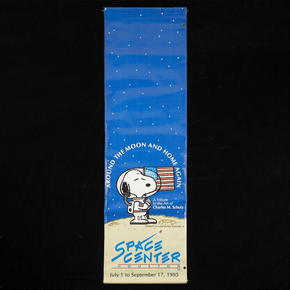
6 MetLife & Peanuts Posters
Group of six posters relating to MetLife and the Peanuts gang: one MetLife advertising campaign proposal for a free kite; one United States map sh...
Two 20th Century reproduction maps of South-West interest, featuring a map of 'Somersetshire', dated '1836', and a map of 'Gloucestershire'. Both ...

Wall atlas about the war of 1866, map composed of several parts, mounted on linen, inscribed in detail upper right "Haack-Hertzberg, Großer Histor...

Charles Schulz (American, 1922-2000). Original ink on paper drawing depicting Snoopy as the Flying Ace atop his doghouse, ca. 1970s. Signed along ...

Charles Schulz (American, 1922-2000). Original ink on paper drawing depicting Snoopy and Charlie visiting Lucy's therapy stand, ca. 1970s. Signed ...

Charles Schulz (American, 1922-2000). Original ink on paper drawing depicting Schroeder at his piano. Signed along the lower right. With a certifi...

Charles Schulz (American, 1922-2000). Original ink on paper drawing of Linus with his beloved blanket. Signed along the lower right. With a certif...

A collection of eleven 19th century maps of Russia and Siberia, some hand-coloured or with coloured borders. The lot including eight examples by J...

Charles Graham (American, 1852-1911). Hand-colored wood engraving titled "Sketches from Minneapolis, Minnesota" depicting Lake Minnetonka, the por...

Hand-colored engraving titled "St. Paul, From Dayton's Bluff," from the book "Picturesque America," published in 1874. Depicting a steamship on th...

Lot 46
A 19th century embroidered map of England and Wales with a floral border 54cm diameter. mounted in a
A 19th century embroidered map of England and Wales with a floral border 54cm diameter. mounted in a gilded frame. Some discolouration and marks

Group of three items relating to Camp Snoopy. One gift bag from Snoopy's Gallery and Gift Shop and one gift bag from Minnesota Camp Snoopy. One ca...

Lot 64
An early 19th century map of the county of Wiltshire by Christopher Greenwood 109cm x 150cm Corner
64An early 19th century map of the county of Wiltshire by Christopher Greenwood 109cm x 150cm Corner
An early 19th century map of the county of Wiltshire by Christopher Greenwood 109cm x 150cmCorner missing around the title. marks and damages.

17th Old Print Antique Original Color Gravure Attack Boulogne-sur-mer Jean 1788, Engraving - paper, Print, Author - Antoine Louis Francois Sergent...

Lot 87
Portrait of Charles de Cossé, Count of Brissac (1505/6-1563) French Soldier, Courtier & Marshal
Portrait of Charles de Cossé, Count of Brissac (1505/6-1563) French Soldier, Courtier & Marshal of France, Engraving - paper, Print, 1788 year, Au...

Lot 92
Cepparello, Isole e Olena
1998 - 1 Bottiglia (75cl) 1999 - 1 Bottiglia (75cl)2000 - 1 Bottiglia (75cl)

Lot 103
Purchas (Thomas) The Communicants duty. Set forth in eight sermons, preached at Kings-Lynne in No...
Purchas (Thomas) The Communicants duty. Set forth in eight sermons, preached at Kings-Lynne in Norfolk, woodcut head-pieces and decorative initial...

Hand-colored map depicting Minnesota and the un-unified Dakota territories. Parts of Wisconsin and Iowa are seen in the margins. Surrounded by a b...

Lot 111
County Map of Minnesota ca. 1877
Antique county map of the state of Minnesota, ca. 1877. Hand-colored in red, blue, and pink. Surrounded by a decorative border of ripe grape vines...

One group photograph depicting a postmaster's convention, ca. 1926. Inscribed "Postmaster's Convention, Curtis Hotel, June 18, 1926, Minneapolis, ...

Lot 134
Darell (Rev. William) The History of Dover Castle, Southampton, for H. Hooper, 1786; and another (2)
Darell (Rev. William) The History of Dover Castle, engraved title with vignette, 8 engraved plates, folding engraved map, a few spots and some lea...

Lot 141
JAN DAVIDSZ DE HEEM (seguace di)
(Utrecht, 1606 - Anversa, 1684)Natura mortaOlio su tela, cm 80X112Provenienza: Probabilmente Parigi, Galleria Charpentier (1956, come attribuito a...

Lot 153
Schleswig Holstein. Nordfriesland. Original kolorierte Kupferstichkarte von Joh. Mejer aus C.
Schleswig Holstein. Nordfriesland. Original kolorierte Kupferstichkarte von Joh. Mejer aus C. Danckwerth, Newe Landesbeschreibung ..., 1652. 2 Kar...

Saxton, Christopher (c.1540-c.1610) & William Hole (d. 1624) - A 17th century etched & hand coloured map of Oxfordshire. The map reading: Oxoniens...

Lot 180
Churchill (Sir Winston Spencer) The British Gazette, nos. 1-8 (all published), 5 - 13th May, 1926
180Churchill (Sir Winston Spencer) The British Gazette, nos. 1-8 (all published), 5 - 13th May, 1926
Churchill (Sir Winston Spencer, editor) The British Gazette, nos. 1-8 (all published), loose as issued, light browning, some spotting, a few edges...

Lot 192
The War in India: Despatches of the Rt. Hon. Lt. General Viscount Hardinge, Governor-General of ...
The War in India: Despatches of the Rt. Hon. Lt. General Viscount Hardinge, Governor-General of India, the Right-Honourable General Lord Gough, Co...

Lot 223
Gillray (James) New Morality, -or- The promis'd Installment of the High-Priest of the Theophilant...
Gillray (James) New Morality, -or- The promis'd Installment of the High-Priest of the Theophilanthropes, extended folding plate for the Anti-Jacob...

Lot 236
Britain.- Bartholomew (John) Bartholomew's New Reduced Survey Tourists & Cyclists, 36 maps of Bri...
Britain.- Bartholomew (John) Bartholomew's New Reduced Survey Tourists & Cyclists, 36 maps of British Isles, dissected and mounted on cloth, some ...

Britain.- Camden (William) Britannia, 4 vol., engraved plates and maps, heavily damp-stained with some defects, repairs and loss, ex-library copy ...

London.- Cary (John) Cary's New Pocket Plan of London, Westminster and Southwark, plan of London with keys below for 'Penny Post Receiving Houses'...

Lot 244
London.- Cary (John) Cary’s New and Accurate Plan of London and Westminster, the Borough of South...
London.- Cary (John) Cary’s New and Accurate Plan of London and Westminster, the Borough of Southwark and parts adjacent..., : viz. Kensington, Ch...

Lot 245
London.- Homann (Johann Baptist) Accurater Prospect und Grundris der Konigl: Gros - Britanisch: H...
London.- Homann (Johann Baptist) Accurater Prospect und Grundris der Konigl: Gros - Britanisch: Haupt und Residentz stadt London..., map of London...

Lot 246
London.- Langley (Edward, & Belch, William) Langley and Belch's New Map of London, engraved map, ...
London.- Langley (Edward, & Belch, William) Langley and Belch's New Map of London, first edition, map of London with 24 uncoloured engraved vignet...

Lot 247
London.- Newcourt (Richard), After. An Exact Delineation of the Cities of London and Westminster ...
London.- Newcourt (Richard), After. An Exact Delineation of the Cities of London and Westminster and the Suburbs Thereof..., plan of London and th...

Lot 248
London.- River Thames.- Tombleson (William) Tombleson’s Panoramic Map of the River Thames and Med...
London.- River Thames.- Tombleson (William) Tombleson’s Panoramic Map of the River Thames and Medway, vertical strip-map of the Thames from Cirenc...

Lot 262
India.- Laurie & Whittle (publishers) A New Map of the Jaghir Lands, on the Coast of Coromandel, ...
India.- Laurie & Whittle (publishers) A New Map of the Jaghir Lands, on the Coast of Coromandel, The Territory Belonging To The East India Company...

Lot 268
Voyages.- Dampier (William) A New Voyage Round the World... the Isthmus of America..., vol.1 (of ...
Voyages.- Dampier (William) A New Voyage Round the World... the Isthmus of America..., vol.1 (of 3), the third edition corrected, 5 engraved maps ...

Edward Curtis (American, 1868-1952). Photogravure labeled "Members of the Expedition on St. Matthew Island" depicting three views of various membe...

After Michael Drayton (British, 1563-1631) - An etching on paper and hand coloured map of Glocestershyre (sic - Gloucestershire), from the poetic ...

Printed map and political poster headed as "Alcatraz - Indian Land" depicting Alcatraz Island and the events that occurred during the occupation b...

Engraving with text depicting a bustling Native American market. From Theodor de Bry (Netherlandish, 1528-1598), Thomas Hariot (British, ca. 1560-...

1st millennium B.C. A round-section rod coiled and partly flattened to form a hair ornament. See Taylor, J.T., Bronze Age Goldwork of the British ...

Lot 309
A PAIR OF REGENCY G. & J. CARY'S CELESTIAL AND TERRESTRIAL FLOOR GLOBESLondon, first quarter 19t...
A PAIR OF REGENCY G. & J. CARY'S CELESTIAL AND TERRESTRIAL FLOOR GLOBES London, first quarter 19th century The celestial globe with cartouche read...

David Michael Jones (1895-1974) Map of the Third Voyage wood engraving 19 x 16cm.

Lot 370
India:- King (W) and Pope (T.A.) Compilers. 'Gold, Copper and Lead in the Chota Nagpore and adjacent
India:- King (W) and Pope (T.A.) Compilers. 'Gold, Copper and Lead in the Chota Nagpore and adjacent Country with map (large folding) showing the...
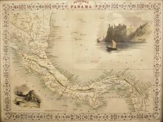
A 19th century circa 1850 Isthmus of Panama map by J. Rapkin. The illustrations by H. Warren, drawn and engraved by J. Rapkin and J. Wrightson. T...

Lot 376
Reisen. Deutschlandkarte. Roost, J. B. Neue Wand – Karte von Deutschland den Königreichen Holland u.
Reisen. Deutschlandkarte. Roost, J. B. Neue Wand – Karte von Deutschland den Königreichen Holland u. Belgien und der Schweiz, sammt den angrenzend...

Lot 422
Homer 'Ilias and Odyssea' Joshua Barnes Ed. 2 vols. Crownfield, Cambridge 1711. 4to. allegorical
Homer 'Ilias and Odyssea' Joshua Barnes Ed. 2 vols. Crownfield, Cambridge 1711. 4to. allegorical engraved frontispiece in Vol 1. text in Greek wit...

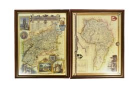
A 19th century circa 1850 map of Scotland. The map was illustrated by N. Whittock, drawn and engraved by J Rapkin. The map features excellent deta...

Vayrac (Abbé Jean de). 'Etat Present de L'Espagne ou L'on voit une geographie Historique du pays...'. 3 vols. small 8vo. Steenhouwer and Uytwerp, ...

Lot 465
David Roberts Print
19th century A.D. Printed map of Egypt and Nubia with locations marked of the sketches of David Roberts, RA on his 1849 expedition; mounted in a g...

Lot 466
W & A.K. Johnston's Railway Map of England and Wales, 13th Edition. The Scarborough Company,
W & A.K. Johnston's Railway Map of England and Wales, 13th Edition. The Scarborough Company, London c1930

Johnston (Robert). 'Historia Rerum Britannicarum ut et Multarum Gallicarum, Belgicarum and Germanicarum...'. Ravestyn, Amsterdam 1655. 737pp plus ...

rettangolare e ornato da grande cartouche floreale in marmi policromi diversi, in bordo filettato, montato su tavolo su base con cornice a legno p...

Coxe (William) Travels in Poland, Russia, Sweden and Denmark. Illustrated by charts and engravings. 3/5 vols. 5th Ed. Cadell and Davies, London 18...

Lot 530
Seven Years War (1756-1763) Anon:- 'Theatre de la Guerre Derniere en Allemagne...' 2nd Ed. 6 vols.
Seven Years War (1756-1763) Anon:- 'Theatre de la Guerre Derniere en Allemagne...' 2nd Ed. 6 vols. 12mo. Langlois, Paris 1768 with c70. folding ma...

Lot 545
Smith (C) 'Smith's Classical Atlas containing District Maps of the Countries described in Ancient
545Smith (C) 'Smith's Classical Atlas containing District Maps of the Countries described in Ancient
Smith (C) 'Smith's Classical Atlas containing District Maps of the Countries described in Ancient History both Sacred and Profane' London 1820. Co...

Quantity of Roleplaying maps & figures. Consisiting of paper & card maps to include Dungeons & Dragons, metal & plastic figures. Unchecked for com...